D.Ana Railway Bridge over the Zambezi River
- Location: Mutarara, Zambezia Province, Mozambique
- Solution: Bridges, Geotechnics, Asset Management
- Type: Rehabilitation, Testing, prospection and studies
- Promoter: CFM Ports and railways of Mozambique
- Client: CFM Ports and railways of Mozambique
- Scope: Rehabilitation design projects of rail bridges, structural assessment, topographic and bathymetric surveys, detailed plans, visual and underwater inspections
- Area: 14 708m2 of deck surface
- Project: 2015/2016
- Construction: 2016
- Dimension: 3677m long, 80m max span
- See on Google Maps
D.Ana Railway Bridge over the Zambezi River
- Location: Mutarara, Zambezia Province, Mozambique
- Solution: Bridges, Geotechnics, Asset Management
- Type: Rehabilitation, Testing, prospection and studies
- Promoter: CFM Ports and railways of Mozambique
- Client: CFM Ports and railways of Mozambique
- Scope: Rehabilitation design projects of rail bridges, structural assessment, topographic and bathymetric surveys, detailed plans, visual and underwater inspections
- Area: 14 708m2 of deck surface
- Project: 2015/2016
- Construction: 2016
- Dimension: 3677m long, 80m max span
- Ver no Google Maps
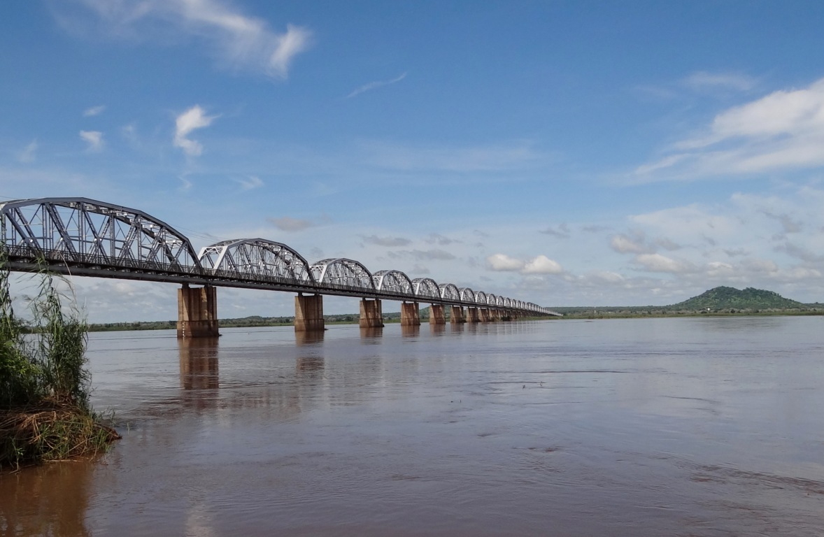
The D. Ana railway bridge is a reference in Austral Africa’s railway structures as it is one of the longest structures. The bridge connects the settlements of Sena (South bank) and Mutarara (North bank) and it is located in the centre of Mozambique. It has a strategic importance in the Development Corridor of the Centre.
The bridge was constructed by the Portuguese administration and opened to rail traffic in 1935. But in the 80’s train services suddenly stopped due to civil war. The bridge suffered sabotage and several spans have collapsed.
In 1995 after rehabilitation works it was converted into a motorway. But, following a lack of maintenance, in 2006 it had reached pre-collapse condition. The bridge was then again rehabilitated and returned to railway traffic.
However, the bridge owner intends to increase its resistance and upgrade the overall structure to match the steadily increasing traffic demands and also for the modernization of the railway corridor.
The crossing is divided in three different structures: the main bridge (2992m), composed by a succession of 40 bowstring spans where 33 are 80m long and the other 7 spans have 50m of extension, and the access viaducts in the Southern (563m) and Northern (122m) banks composed by two “I” steel sections girders and various expansion joints. The piers were founded either over direct footings or drilled shafts. The crossing has a lateral pedestrian walkway, also used as a cycleway, surpassing 3000 people daily. In this river section, the Zambezi’s minor flood plain is just 1400m wide!
The conceptual rehabilitation design project already developed included visual inspections and subaquatic surveys with multi-beam sonar, geotechnical surveys, structural assessment, guidelines and specifications for reinforcement and repair design project.